Geolocate

富世街道 topographic map

Interactive map

Click on the map to display elevation.

About this map

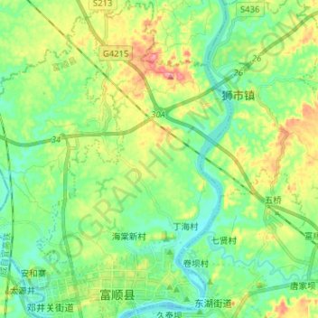
Name: 富世街道 topographic map, elevation, terrain.

Location: 富世街道, 富顺县, 自贡市, 四川省, 中国 (29.17573 104.93971 29.28678 105.01770)

Average elevation: 300 m

Minimum elevation: 261 m

Maximum elevation: 380 m

Other topographic maps

Click on a map to view its topography, its elevation and its terrain.

三块碑

中国 > 四川省 > 富顺县

三块碑, 富顺县, 自贡市, 四川省, 中国

Average elevation: 302 m

万坳

中国 > 四川省 > 富顺县 > 龙万乡

万坳, 龙万乡, 富顺县, 自贡市, 四川省, 中国

Average elevation: 317 m

虎头

中国 > 四川省 > 富顺县 > 怀德镇

虎头, 怀德镇, 富顺县, 自贡市, 四川省, 中国

Average elevation: 277 m

安溪镇

中国 > 四川省 > 富顺县

安溪镇, 富顺县, 自贡市, 四川省, 中国

Average elevation: 315 m

安和寨

中国 > 四川省 > 富顺县 > 邓井关街道

安和寨, 邓井关街道, 富顺县, 自贡市, 四川省, 中国

Average elevation: 288 m

富顺县

中国 > 四川省 > 富顺县

富顺县, 富世街道, 富顺县, 自贡市, 四川省, 中国

Average elevation: 318 m

李桥镇

中国 > 四川省 > 富顺县

李桥镇, 富顺县, 自贡市, 四川省, 中国

Average elevation: 349 m