Geolocate

龙泉街道 topographic map

Interactive map

Click on the map to display elevation.

About this map

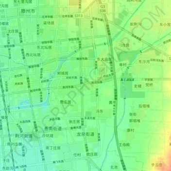
Name: 龙泉街道 topographic map, elevation, terrain.

Location: 龙泉街道, 滕州市, 枣庄市, 山东省, 中国 (35.04831 117.15943 35.11819 117.21766)

Average elevation: 73 m

Minimum elevation: 57 m

Maximum elevation: 102 m

Other topographic maps

Click on a map to view its topography, its elevation and its terrain.

滕州市莲青山省级地质公园

中国 > 山东省 > 滕州市

滕州市莲青山省级地质公园, 滕州市, 枣庄市, 山东省, 中国

Average elevation: 235 m

南沙河镇

中国 > 山东省 > 滕州市

南沙河镇, 滕州市, 枣庄市, 山东省, 中国

Average elevation: 64 m

北辛街道

中国 > 山东省 > 滕州市

北辛街道, 滕州市, 枣庄市, 山东省, 277599, 中国

Average elevation: 72 m

张汪镇

中国 > 山东省 > 滕州市

张汪镇, 滕州市, 枣庄市, 山东省, 中国

Average elevation: 44 m

滕州市

中国 > 山东省 > 滕州市

滕州市, 枣庄市, 山东省, 277599, 中国

Average elevation: 86 m