
Barling topographic map
Interactive map
Click on the map to display elevation.
About this map
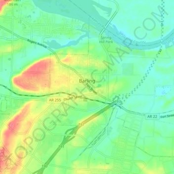
Name: Barling topographic map, elevation, terrain.
Location: Barling, Sebastian County, Arkansas, 72923, United States (35.30040 -94.32367 35.35486 -94.24268)
Average elevation: 136 m
Minimum elevation: 112 m
Maximum elevation: 184 m
Other topographic maps
Click on a map to view its topography, its elevation and its terrain.
Hackett
United States > Arkansas > Sebastian County
Hackett, Sebastian County, Arkansas, United States
Average elevation: 167 m
Lavaca
United States > Arkansas > Sebastian County
Lavaca, Sebastian County, Arkansas, 72941, United States
Average elevation: 134 m
Fort Smith
United States > Arkansas > Sebastian County
Fort Smith, Sebastian County, Arkansas, United States
Average elevation: 140 m
Fort Smith
United States > Arkansas > Sebastian County > Fort Smith
Fort Smith, Sebastian County, Arkansas, 72901, United States
Average elevation: 163 m
Greenwood
United States > Arkansas > Sebastian County
Greenwood, Sebastian County, Arkansas, 72936, United States
Average elevation: 179 m