Geolocate

海丰县 topographic map

Interactive map

Click on the map to display elevation.

About this map

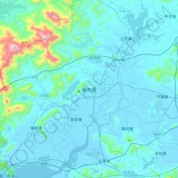
Name: 海丰县 topographic map, elevation, terrain.

Location: 海丰县, 汕尾市, 广东省, 中国 (22.80973 115.15821 23.12973 115.47821)

Average elevation: 107 m

Minimum elevation: -4 m

Maximum elevation: 1,273 m

Other topographic maps

Click on a map to view its topography, its elevation and its terrain.

金钩

中国 > 广东省 > 海丰县 > 海丰县

金钩, 海丰县, 汕尾市, 广东省, 中国

Average elevation: 130 m

桂望村

中国 > 广东省 > 海丰县 > 海丰县

桂望村, 海丰县, 汕尾市, 广东省, 中国

Average elevation: 28 m

赤石街道

中国 > 广东省 > 海丰县 > 赤石街道

赤石街道, 海丰县, 汕尾市, 广东省, 中国

Average elevation: 80 m

南山村

中国 > 广东省 > 海丰县

南山村, 海丰县, 汕尾市, 广东省, 中国

Average elevation: 54 m

鲘门街道

中国 > 广东省 > 海丰县 > 鲘门街道

鲘门街道, 海丰县, 汕尾市, 广东省, 中国

Average elevation: 31 m