
洞口县 topographic map
Interactive map
Click on the map to display elevation.
About this map
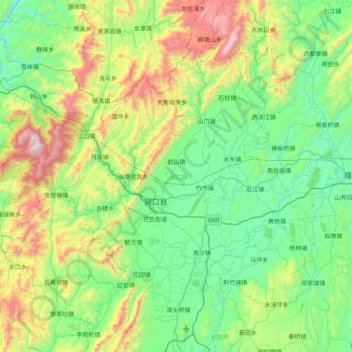
Name: 洞口县 topographic map, elevation, terrain.
Location: 洞口县, 邵阳市, 湖南省, 中国 (26.85696 110.14179 27.37113 110.94167)
Average elevation: 576 m
Minimum elevation: 137 m
Maximum elevation: 1,918 m
洞口县地处雪峰山脉东麓,资水上游;地理上西北部为雪峰山脉,平均海拔500米以上,千米以上山峰百余座,普子垴海拔1821米,为辖境至高点。境内大小溪流130多条,分属资水和沅水二大水系,主要河流有资水、蓼水河、平溪江、黄泥江和公溪河。
Other topographic maps
Click on a map to view its topography, its elevation and its terrain.
湘潭市雨湖区渡佳坝工程管理所
湘潭市雨湖区渡佳坝工程管理所, 烧汤河, 响塘乡, 雨湖区, 湘潭市, 湖南省, 中国
Average elevation: 47 m