
岳阳县 topographic map
Interactive map
Click on the map to display elevation.
About this map
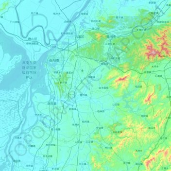
Name: 岳阳县 topographic map, elevation, terrain.
Location: 岳阳县, 岳阳市, 湖南省, 414100, 中国 (28.95312 112.76645 29.51294 113.73249)
Average elevation: 112 m
Minimum elevation: 17 m
Maximum elevation: 1,209 m
Other topographic maps
Click on a map to view its topography, its elevation and its terrain.
湘潭市雨湖区渡佳坝工程管理所
湘潭市雨湖区渡佳坝工程管理所, 烧汤河, 响塘乡, 雨湖区, 湘潭市, 湖南省, 中国
Average elevation: 47 m