
武陵源区 topographic map
Interactive map
Click on the map to display elevation.
About this map
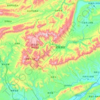
Name: 武陵源区 topographic map, elevation, terrain.
Location: 武陵源区, 张家界市, 湖南省, 427400, 中国 (29.22085 110.29932 29.45643 110.69226)
Average elevation: 508 m
Minimum elevation: 133 m
Maximum elevation: 1,251 m
Other topographic maps
Click on a map to view its topography, its elevation and its terrain.
湘潭市雨湖区渡佳坝工程管理所
湘潭市雨湖区渡佳坝工程管理所, 烧汤河, 响塘乡, 雨湖区, 湘潭市, 湖南省, 中国
Average elevation: 47 m