
玉函路社区 topographic map
Interactive map
Click on the map to display elevation.
About this map
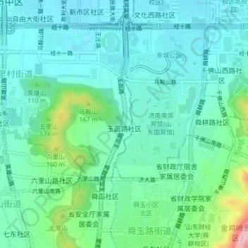
Name: 玉函路社区 topographic map, elevation, terrain.
Location: 玉函路社区, 四里村街道, 市中区, 济南市, 山东省, 250000, 中国 (36.63169 116.99649 36.64360 117.00871)
Average elevation: 85 m
Minimum elevation: 45 m
Maximum elevation: 232 m
Other topographic maps
Click on a map to view its topography, its elevation and its terrain.