
张溪镇 topographic map
Interactive map
Click on the map to display elevation.
About this map
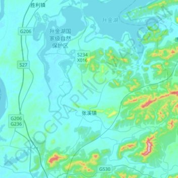
Name: 张溪镇 topographic map, elevation, terrain.
Location: 张溪镇, 东至县, 池州市, 安徽省, 247200, 中国 (30.20118 116.99498 30.39558 117.26079)
Average elevation: 42 m
Minimum elevation: 4 m
Maximum elevation: 433 m
Other topographic maps
Click on a map to view its topography, its elevation and its terrain.