
Thank you for supporting this site ❤️
Make a donation
Make a donation
Ashkelon topographic map
Click on the map to display elevation.
Thank you for supporting this site ❤️
Make a donation
Make a donation
About this map
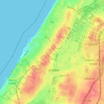
Name: Ashkelon topographic map, elevation, terrain.
Location: Ashkelon, Ashkelon Subdistrict, South District, Israel (31.64460 34.54782 31.70559 34.60656)
Average elevation: 30 m
Minimum elevation: 0 m
Maximum elevation: 69 m
Thank you for supporting this site ❤️
Make a donation
Make a donation
Other topographic maps
Click on a map to view its topography, its elevation and its terrain.