
Thank you for supporting this site ❤️
Make a donation
Make a donation
Netivot topographic map
Click on the map to display elevation.
Thank you for supporting this site ❤️
Make a donation
Make a donation
About this map
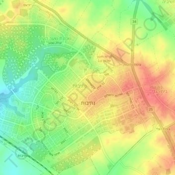
Name: Netivot topographic map, elevation, terrain.
Location: Netivot, Beersheba Subdistrict, South District, Israel (31.40015 34.55509 31.44345 34.63113)
Average elevation: 131 m
Minimum elevation: 89 m
Maximum elevation: 170 m
Thank you for supporting this site ❤️
Make a donation
Make a donation
Other topographic maps
Click on a map to view its topography, its elevation and its terrain.