
Zamboanga del Norte topographic map
Interactive map
Click on the map to display elevation.
Zamboanga del Norte
It has an average elevation of 243.8 metres (800 ft), with Mount Dabiak in Katipunan as the highest peak at 2,600 metres (8,500 ft). Other parts, near the coastlines, are plains. The province's irregular coastline runs some 400 kilometres (250 mi) from north to south.
About this map
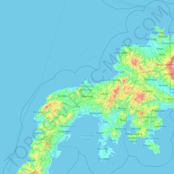
Name: Zamboanga del Norte topographic map, elevation, terrain.
Location: Zamboanga del Norte, Zamboanga Peninsula, Philippines (7.14683 121.78584 8.99718 123.58703)
Average elevation: 78 m
Minimum elevation: -2 m
Maximum elevation: 1,651 m
Other topographic maps
Click on a map to view its topography, its elevation and its terrain.
Mount Mayon
Philippines > Albay > Tabaco
On February 23, 2023, a twin engine Cessna 340 airplane owned by the Energy Development Corporation departed Bicol International Airport in the early morning on an executive flight to the capital Manila. A few minutes after takeoff, while climbing to an altitude of 6,000 ft (1,800 m), it impacted the rocky…
Average elevation: 1,696 m