
Macabud topographic map
Click on the map to display elevation.
About this map
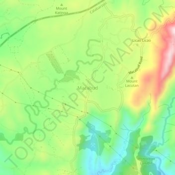
Name: Macabud topographic map, elevation, terrain.
Location: Macabud, Rizal, Calabarzon, Philippines (14.77762 121.11953 14.81762 121.15953)
Average elevation: 225 m
Minimum elevation: 75 m
Maximum elevation: 440 m
Other topographic maps
Click on a map to view its topography, its elevation and its terrain.
Taytay
The shape of Taytay is rectangular – trapezoidal with gently hilly rolling terrain on its eastern side while relatively flat on its south-western side, including the poblacion. The municipality's highest elevation ranges from 200 to 255 meters which is situated along the inner north-eastern hills of Barangay…
Average elevation: 37 m