
Thyolo topographic map
Interactive map
Click on the map to display elevation.
About this map
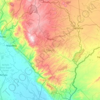
Name: Thyolo topographic map, elevation, terrain.
Location: Thyolo, Southern Region, Malawi, Malawi (-16.41078 34.90256 -15.84607 35.33082)
Average elevation: 552 m
Minimum elevation: 49 m
Maximum elevation: 1,441 m
Other topographic maps
Click on a map to view its topography, its elevation and its terrain.
Lake Chilwa
Lake Chilwa, Zomba, Southern Region, Malawi
Average elevation: 647 m