
Reichraming topographic map
Interactive map
Click on the map to display elevation.
About this map
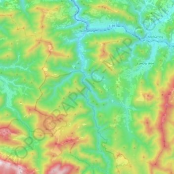
Name: Reichraming topographic map, elevation, terrain.
Location: Reichraming, Bezirk Steyr-Land, 4462, Österreich (47.76535 14.39144 47.91829 14.53170)
Average elevation: 800 m
Minimum elevation: 346 m
Maximum elevation: 1,776 m
Die Ausdehnung von Reichraming beträgt von Nord nach Süd 10,4 km, von West nach Ost 16,9 km, 79,2 % der Fläche sind bewaldet, 11,5 % landwirtschaftlich genutzt. Das Ortszentrum liegt auf 356 m Höhe und befindet sich am Fluss Reichramingbach. Reichraming wird durch die Enns in zwei Ortschaften, Arzberg und Reichraming, geteilt.
Other topographic maps
Click on a map to view its topography, its elevation and its terrain.
Rotstein
Österreich > Bezirk Steyr-Land > Großraming
Rotstein, Großraming, Bezirk Steyr-Land, 4463, Österreich
Average elevation: 618 m
Maria Neustift
Österreich > Bezirk Steyr-Land
Maria Neustift, Bezirk Steyr-Land, 4443, Österreich
Average elevation: 634 m
Obsweyer
Österreich > Bezirk Steyr-Land
Obsweyer, Weyer, Bezirk Steyr-Land, 3335, Österreich
Average elevation: 561 m
Bad Hall
Österreich > Bezirk Steyr-Land
Bad Hall, Bezirk Steyr-Land, 4540, Österreich
Average elevation: 389 m
Rohr im Kremstal
Österreich > Bezirk Steyr-Land
Rohr im Kremstal, Bezirk Steyr-Land, 4532, Österreich
Average elevation: 367 m
Gaflenz
Österreich > Bezirk Steyr-Land
Gaflenz, Bezirk Steyr-Land, 3334, Österreich
Average elevation: 674 m
Saaß
Österreich > Bezirk Steyr-Land
Saaß, Aschach an der Steyr, Bezirk Steyr-Land, 4421, Österreich
Average elevation: 389 m