
Obsweyer topographic map
Interactive map
Click on the map to display elevation.
About this map
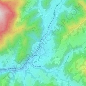
Name: Obsweyer topographic map, elevation, terrain.
Location: Obsweyer, Weyer, Bezirk Steyr-Land, 3335, Österreich (47.84614 14.65226 47.88614 14.69226)
Average elevation: 561 m
Minimum elevation: 385 m
Maximum elevation: 1,061 m
Other topographic maps
Click on a map to view its topography, its elevation and its terrain.
Rotstein
Österreich > Bezirk Steyr-Land > Großraming
Rotstein, Großraming, Bezirk Steyr-Land, 4463, Österreich
Average elevation: 618 m
Reichraming
Österreich > Bezirk Steyr-Land
Reichraming, Bezirk Steyr-Land, 4462, Österreich
Average elevation: 800 m
Maria Neustift
Österreich > Bezirk Steyr-Land
Maria Neustift, Bezirk Steyr-Land, 4443, Österreich
Average elevation: 634 m
Bad Hall
Österreich > Bezirk Steyr-Land
Bad Hall, Bezirk Steyr-Land, 4540, Österreich
Average elevation: 389 m
Rohr im Kremstal
Österreich > Bezirk Steyr-Land
Rohr im Kremstal, Bezirk Steyr-Land, 4532, Österreich
Average elevation: 367 m
Gaflenz
Österreich > Bezirk Steyr-Land
Gaflenz, Bezirk Steyr-Land, 3334, Österreich
Average elevation: 674 m
Saaß
Österreich > Bezirk Steyr-Land
Saaß, Aschach an der Steyr, Bezirk Steyr-Land, 4421, Österreich
Average elevation: 389 m