
Make a donation
Guimaras topographic map
Click on the map to display elevation.
Make a donation
Guimaras
Mount Bontoc is the highest point in the province of Guimaras with an elevation of 892 ft (272 m) above sea level, located in municipality of Sibunag. Mount Dinulman is the second highest mountain with an elevation of 879 ft (268 m) also located in Sibunag.
Make a donation
About this map
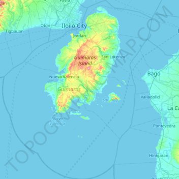
Name: Guimaras topographic map, elevation, terrain.
Location: Guimaras, Western Visayas, Philippines (10.19397 122.33709 10.77440 122.83021)
Average elevation: 13 m
Minimum elevation: -2 m
Maximum elevation: 270 m
Make a donation
Other topographic maps
Click on a map to view its topography, its elevation and its terrain.
Make a donation
Mount Mayon
Philippines > Albay > Tabaco
On February 23, 2023, a twin engine Cessna 340 airplane owned by the Energy Development Corporation departed Bicol International Airport in the early morning on an executive flight to the capital Manila. A few minutes after takeoff, while climbing to an altitude of 6,000 ft (1,800 m), it impacted the rocky…
Average elevation: 1,696 m
Make a donation
Make a donation
Make a donation
Make a donation
Make a donation
Make a donation