
Make a donation
Zeitlarn topographic map
Click on the map to display elevation.
Make a donation
About this map
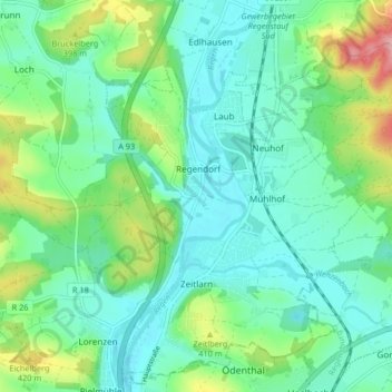
Name: Zeitlarn topographic map, elevation, terrain.
Location: Zeitlarn, Landkreis Regensburg, Bayern, 93197, Deutschland (49.06252 12.08886 49.11413 12.17115)
Average elevation: 365 m
Minimum elevation: 327 m
Maximum elevation: 474 m
Make a donation
Other topographic maps
Click on a map to view its topography, its elevation and its terrain.
Make a donation
Make a donation
Make a donation
Hainsacker
Deutschland > Bayern > Landkreis Regensburg
Altenried | Aschach | Baiern | Benhof | Einhausen | Geiersberg | Gewald | Hainsacker | Harreshof | Hohensand | Hönighausen | Kareth | Kaulhausen | Knieschlag | Landlhof | Lappersdorf | Lorenzen | Oppersdorf | Pielmühle | Rehthal | Rodau | Schinderwies | Schwaighausen | Schwärz | Schwerdnermühle | Steinhof…
Average elevation: 402 m
Make a donation
Holzheim am Forst
Deutschland > Bayern > Landkreis Regensburg > Holzheim am Forst > Holzheim am Forst
Average elevation: 391 m
Make a donation
Wörth an der Donau
Deutschland > Bayern > Landkreis Regensburg > Wörth an der Donau > Wörth an der Donau
Average elevation: 379 m
Make a donation
Wichenbach
Deutschland > Bayern > Landkreis Regensburg > Wörth an der Donau > Tiefenthal
Average elevation: 376 m
Make a donation
Make a donation
Make a donation
Make a donation
Make a donation
Make a donation
Make a donation
Make a donation
Danersdorf
Deutschland > Bayern > Landkreis Regensburg > Regenstauf > Gnadenhof
Average elevation: 482 m
Make a donation
Wenzenbach
Deutschland > Bayern > Landkreis Regensburg > Probstberg > Zeitlhof
Average elevation: 389 m
Kollersried
Deutschland > Bayern > Landkreis Regensburg > Hemau > Laufenthal > Kollersried
Average elevation: 501 m
Make a donation
Neuhaus
Deutschland > Bayern > Landkreis Regensburg > Regenstauf > Diesenbach
Average elevation: 365 m
Make a donation