
Buchenlohe topographic map
Interactive map
Click on the map to display elevation.
About this map
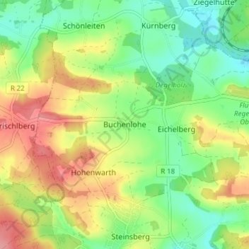
Name: Buchenlohe topographic map, elevation, terrain.
Average elevation: 389 m
Minimum elevation: 347 m
Maximum elevation: 444 m
Other topographic maps
Click on a map to view its topography, its elevation and its terrain.
Eitlbrunn
Deutschland > Bayern > Landkreis Regensburg > Regenstauf
Eitlbrunn, Regenstauf, Landkreis Regensburg, Bayern, 93128, Deutschland
Average elevation: 386 m
Neuhaus
Deutschland > Bayern > Landkreis Regensburg > Regenstauf > Hagenau
Neuhaus, Hagenau, Regenstauf, Landkreis Regensburg, Bayern, 93128, Deutschland
Average elevation: 365 m