
Make a donation
Balâ topographic map
Click on the map to display elevation.
Make a donation
Balâ
Bala (also: Balâ), formerly known as Balbadon, is a municipality and district of Ankara Province, Turkey. Its area is 1,851 km2, and its population is 20,521 (2022). It is 67 km south-east of the city of Ankara. Its elevation is 1,310 m (4,298 ft).
Make a donation
About this map
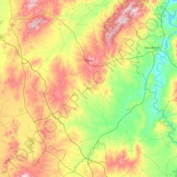
Name: Balâ topographic map, elevation, terrain.
Location: Balâ, Ankara, Central Anatolia Region, 06720, Turkey (39.19594 32.84054 39.73475 33.54517)
Average elevation: 1,034 m
Minimum elevation: 715 m
Maximum elevation: 1,551 m
Make a donation
Other topographic maps
Click on a map to view its topography, its elevation and its terrain.
Make a donation
Make a donation
Make a donation
Make a donation
Gaziantep
The plan introduced several important changes to the city's transportation network. One of the most important was the addition of a rail line to connect Gaziantep to the national rail system. Up to now, Turkish railway construction had ignored Gaziantep (partly because of its mountainous surroundings); a…
Average elevation: 880 m
Make a donation
Make a donation
Make a donation
Make a donation
Make a donation
Make a donation
Make a donation
Make a donation
Make a donation
Make a donation
Make a donation
Make a donation
Marash
Turkey > Dulkadiroğlu > Dulkadiroğlu
At 2,300 m (7,500 ft) elevation, the nearby Yedikuyular Ski Resort offers winter sports activities.[25]
Average elevation: 843 m
Mount Erciyes
The climate of the region is influenced by topography, with the Taurus and Kaçkar Mountains blocking the entry of moisture into Anatolia. Summers are dry and hot and winters wet and cold; in Kayseri, summer temperatures are about 19 °C (66 °F) and winter temperature about 0 °C (32 °F). Precipitation at…
Average elevation: 3,329 m
Make a donation
Make a donation
Make a donation
Make a donation
Make a donation
Make a donation
Make a donation
Make a donation
Make a donation