
Negeri Sembilan topographic map
Interactive map
Click on the map to display elevation.
About this map
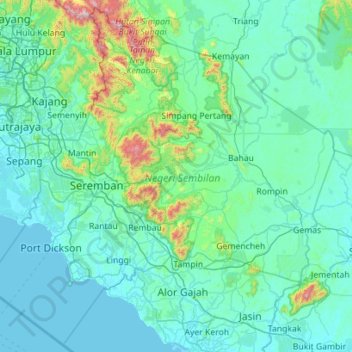
Name: Negeri Sembilan topographic map, elevation, terrain.
Location: Negeri Sembilan, Malaysia (2.21327 101.58008 3.29033 102.70106)
Average elevation: 119 m
Minimum elevation: -1 m
Maximum elevation: 1,403 m
Other topographic maps
Click on a map to view its topography, its elevation and its terrain.
Gunung Angsi
Mount Angsi (Malay: Gunung Angsi) is a mountain which is located between the border between Ulu Bendul, Kuala Pilah District and Senawang, Seremban District in Negeri Sembilan, Malaysia. Part of the Titiwangsa Mountains, it is the seventh tallest mountain in the state, behind Mts. Besar Hantu, Hantu Kecil,…
Average elevation: 552 m
Broga
The hill, approximately 400 m (1,300 ft) in altitude, is notable for its unique appearance as it is rather devoid of trees, which is an uncommon sight amongst the tropical rainforests surrounding the region. Cogongrass typically dominates the summit area. Remnants of burnt out tree trunks indicate that the…
Average elevation: 141 m
Penang Hill
Malaysia > Penang > George Town
A number of hills are covered by Penang Hill, with the highest point being Western Hill that stands at an altitude of 833 meters (2,733 feet) above sea level. Penang Hill is a hilly and forested area that stands out from the lowlands of Malaysia by being hilly and wooded. The area was used as a retreat during…
Average elevation: 568 m
Kuala Lumpur
Located in the centre of Selangor state, Kuala Lumpur was a territory of Selangor State Government. In 1974, Kuala Lumpur was split off from Selangor to form the first Federal Territory governed directly by the Malaysian federal government. Its location in the most developed state on the west coast of…
Average elevation: 80 m