
Thank you for supporting this site ❤️
Make a donation
Make a donation
Sarawak topographic map
Click on the map to display elevation.
Thank you for supporting this site ❤️
Make a donation
Make a donation
About this map
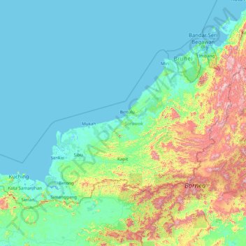
Name: Sarawak topographic map, elevation, terrain.
Location: Sarawak, Malaysia (0.85382 109.53804 5.13323 115.67803)
Average elevation: 228 m
Minimum elevation: -4 m
Maximum elevation: 2,362 m
Thank you for supporting this site ❤️
Make a donation
Make a donation
Other topographic maps
Click on a map to view its topography, its elevation and its terrain.