
Flint River topographic map
Interactive map
Click on the map to display elevation.
About this map
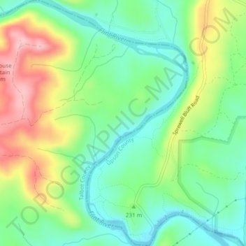
Name: Flint River topographic map, elevation, terrain.
Location: Flint River, Talbot County, Georgia, United States (32.85209 -84.50689 32.88360 -84.47088)
Average elevation: 225 m
Minimum elevation: 163 m
Maximum elevation: 332 m
Other topographic maps
Click on a map to view its topography, its elevation and its terrain.
Talbotton
United States > Georgia > Talbot County
Talbotton, Talbot County, Georgia, United States
Average elevation: 203 m
Junction City
United States > Georgia > Talbot County
Junction City, Talbot County, Georgia, United States
Average elevation: 203 m