
Bozkurt topographic map
Click on the map to display elevation.
Bozkurt
Bozkurt is a municipality and district of Denizli Province, Turkey. Its area is 462 km2, and its population is 12,331 (2022). The town is situated on a plain 52 km (32 mi) east of the city of Denizli. The altitude of the town is 867 m. It is quite close to the Lake Acıgöl and the neighboring town of Çardak and İnceler Kasabası
About this map
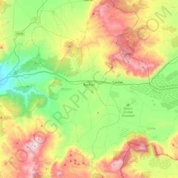
Name: Bozkurt topographic map, elevation, terrain.
Location: Bozkurt, Denizli, Aegean Region, 20380, Turkey (37.65166 29.43383 37.97630 29.72270)
Average elevation: 1,030 m
Minimum elevation: 522 m
Maximum elevation: 1,851 m
Other topographic maps
Click on a map to view its topography, its elevation and its terrain.
Gaziantep
The plan introduced several important changes to the city's transportation network. One of the most important was the addition of a rail line to connect Gaziantep to the national rail system. Up to now, Turkish railway construction had ignored Gaziantep (partly because of its mountainous surroundings); a…
Average elevation: 880 m
Marash
Turkey > Dulkadiroğlu > Dulkadiroğlu
At 2,300 m (7,500 ft) elevation, the nearby Yedikuyular Ski Resort offers winter sports activities.[25]
Average elevation: 843 m
Mount Erciyes
The climate of the region is influenced by topography, with the Taurus and Kaçkar Mountains blocking the entry of moisture into Anatolia. Summers are dry and hot and winters wet and cold; in Kayseri, summer temperatures are about 19 °C (66 °F) and winter temperature about 0 °C (32 °F). Precipitation at…
Average elevation: 3,329 m