
Make a donation
Lata Kijang topographic map
Click on the map to display elevation.
Make a donation
About this map
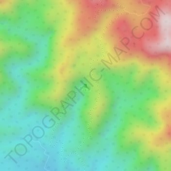
Name: Lata Kijang topographic map, elevation, terrain.
Location: Lata Kijang, Jelebu, Negeri Sembilan, Malaysia (3.19517 101.98772 3.19527 101.98782)
Average elevation: 477 m
Minimum elevation: 243 m
Maximum elevation: 806 m
Make a donation
Other topographic maps
Click on a map to view its topography, its elevation and its terrain.
Make a donation
Make a donation
Make a donation
Make a donation
Perkampungan Budaya Terachi
Malaysia > Negeri Sembilan > Kampung Ayer Hitam > Kampung Parit Istana
Average elevation: 128 m
Make a donation
Jelebu
Amongst the seven districts of Negeri Sembilan, Jelebu is the most mountainous topographically as the Titiwangsa Mountains, the longest mountain range in Malaysia, transverses through the district. As a result, most of its terrain are dominated by forested undulating hills and mountain peaks. The Titiwangsa…
Average elevation: 307 m
Make a donation
Make a donation
Make a donation
Make a donation
Make a donation
Make a donation
Make a donation