
Linxia topographic map
Click on the map to display elevation.
Linxia
The terrain is highlands, mountains and loess hills. Elevation averages 2000 meters above sea-level.
About this map
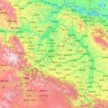
Name: Linxia topographic map, elevation, terrain.
Location: Linxia, Gansu, China (34.90251 102.68311 36.22186 103.86035)
Average elevation: 2,530 m
Minimum elevation: 1,479 m
Maximum elevation: 4,635 m
Other topographic maps
Click on a map to view its topography, its elevation and its terrain.