
合江县 topographic map
Interactive map
Click on the map to display elevation.
About this map
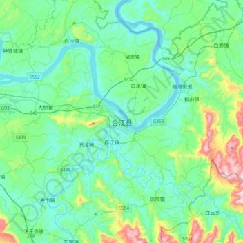
Name: 合江县 topographic map, elevation, terrain.
Location: 合江县, 泸州市, 四川省, 646200, 中国 (28.65462 105.66768 28.97462 105.98768)
Average elevation: 343 m
Minimum elevation: 191 m
Maximum elevation: 1,007 m
Other topographic maps
Click on a map to view its topography, its elevation and its terrain.