
扎古录镇 topographic map
Interactive map
Click on the map to display elevation.
About this map
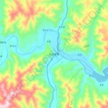
Name: 扎古录镇 topographic map, elevation, terrain.
Location: 扎古录镇, 卓尼县, 甘南藏族自治州, 甘肃省, 中国 (34.61418 103.14395 34.69418 103.22395)
Average elevation: 2,918 m
Minimum elevation: 2,669 m
Maximum elevation: 3,405 m
Other topographic maps
Click on a map to view its topography, its elevation and its terrain.