
Darnestown topographic map
Interactive map
Click on the map to display elevation.
About this map
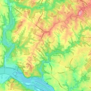
Name: Darnestown topographic map, elevation, terrain.
Location: Darnestown, Montgomery County, Maryland, United States (39.04629 -77.34358 39.13403 -77.24729)
Average elevation: 97 m
Minimum elevation: 47 m
Maximum elevation: 154 m
In the 2000 census, the Census Bureau created a new Census-designated place (CDP) called Darnestown. A Darnestown CDP was also used in the 2010 census. The Darnestown CDP has 16.39 square miles (42.4 km2) of land, which is smaller than the old Darnestown MCD. The CDP uses the Muddy Branch, Turkey Foot Road, and Jones Lane for most of its eastern border instead of rivers further east. The MCD territory between Little Seneca Creek and the north side of Great Seneca Creek is also not part of the Darnestown CDP. Great Seneca Creek remains as the western border. Washington, D.C. is roughly 25 miles (40 km) away. The Travilah and North Potomac CDPs are along the Darnestown CDP's eastern border. The United States Geological Survey lists ten Darnestown-related features, including the Darnestown Census Designated Place with an elevation of 377 feet (115 m) and the Darnestown populated place (a.k.a. Darnestown village) has an elevation of 440 feet (130 m).
Other topographic maps
Click on a map to view its topography, its elevation and its terrain.
Silver Spring
United States > Maryland > Montgomery County > Silver Spring
Silver Spring, Montgomery County, Maryland, United States
Average elevation: 86 m
Gaithersburg
United States > Maryland > Montgomery County
Gaithersburg, Montgomery County, Maryland, United States
Average elevation: 137 m
Laytonsville
United States > Maryland > Montgomery County
Laytonsville, Montgomery County, Maryland, United States
Average elevation: 172 m
Damascus
United States > Maryland > Montgomery County
Damascus, Montgomery County, Maryland, 20872, United States
Average elevation: 204 m
Clarksburg
United States > Maryland > Montgomery County
Clarksburg, Montgomery County, Maryland, United States
Average elevation: 166 m
White Oak
United States > Maryland > Montgomery County
White Oak, Montgomery County, Maryland, 20904, United States
Average elevation: 96 m
Montgomery Village
United States > Maryland > Montgomery County
Montgomery Village, Montgomery County, Maryland, 20886, United States
Average elevation: 139 m
Kemp Mill
United States > Maryland > Montgomery County
Kemp Mill, Montgomery County, Maryland, 20901, United States
Average elevation: 104 m
Flower Hill
United States > Maryland > Montgomery County > Redland
Flower Hill, Redland, Montgomery County, Maryland, 20879, United States
Average elevation: 147 m
Fairland
United States > Maryland > Montgomery County
Fairland, Montgomery County, Maryland, United States
Average elevation: 111 m
Quail Ridge
United States > Maryland > Montgomery County > Montgomery Village
Quail Ridge, Montgomery Village, Montgomery County, Maryland, 20876, United States
Average elevation: 133 m
Cabin John
United States > Maryland > Montgomery County
Cabin John, Montgomery County, Maryland, 20818, United States
Average elevation: 48 m
Chevy Chase Village
United States > Maryland > Montgomery County
Chevy Chase Village, Montgomery County, Maryland, United States
Average elevation: 99 m
Layhill
United States > Maryland > Montgomery County
Layhill, Montgomery County, Maryland, 20906, United States
Average elevation: 116 m
Glenmont
United States > Maryland > Montgomery County
Glenmont, Montgomery County, Maryland, 20902, United States
Average elevation: 109 m
Redland
United States > Maryland > Montgomery County
Redland, Montgomery County, Maryland, 20855, United States
Average elevation: 139 m
Cloverly
United States > Maryland > Montgomery County
Cloverly, Montgomery County, Maryland, 20905, United States
Average elevation: 139 m
Dickerson
United States > Maryland > Montgomery County
Dickerson, Montgomery County, Maryland, 20842, United States
Average elevation: 111 m
Glen Echo
United States > Maryland > Montgomery County
Glen Echo, Montgomery County, Maryland, 20812, United States
Average elevation: 55 m
Colesville
United States > Maryland > Montgomery County
Colesville, Montgomery County, Maryland, 20904, United States
Average elevation: 117 m
Aspen Hill
United States > Maryland > Montgomery County
Aspen Hill, Montgomery County, Maryland, 20906, United States
Average elevation: 114 m
Colesville
United States > Maryland > Montgomery County > Colesville
Colesville, Montgomery County, Maryland, 20904, United States
Average elevation: 113 m
Woodstock Equestrian Park
United States > Maryland > Montgomery County
Woodstock Equestrian Park, 20207, Montgomery County, Maryland, 20842, United States
Average elevation: 124 m
Germantown
United States > Maryland > Montgomery County
Germantown, Montgomery County, Maryland, 20874, United States
Average elevation: 136 m
Patuxent River State Park
United States > Maryland > Montgomery County
Patuxent River State Park, Montgomery County, Maryland, United States
Average elevation: 169 m
Deerfield
United States > Maryland > Montgomery County > Potomac
Deerfield, Potomac, Montgomery County, Maryland, 20817, United States
Average elevation: 84 m
South Kensington
United States > Maryland > Montgomery County
South Kensington, Montgomery County, Maryland, United States
Average elevation: 92 m
Kemp Mill Estates
United States > Maryland > Montgomery County > Kemp Mill
Kemp Mill Estates, Kemp Mill, Montgomery County, Maryland, 20902, United States
Average elevation: 107 m
Farmlands
United States > Maryland > Montgomery County > Travilah
Farmlands, Travilah, Montgomery County, Maryland, United States
Average elevation: 93 m
Damascus
United States > Maryland > Montgomery County > Damascus
Damascus, Montgomery County, Maryland, 20872, United States
Average elevation: 195 m
Germantown
United States > Maryland > Montgomery County > Germantown
Germantown, Montgomery County, Maryland, United States
Average elevation: 130 m
Garrett Park
United States > Maryland > Montgomery County
Garrett Park, Montgomery County, Maryland, 20896, United States
Average elevation: 90 m
Chevy Chase View
United States > Maryland > Montgomery County
Chevy Chase View, Montgomery County, Maryland, United States
Average elevation: 82 m
Hunting Hill
United States > Maryland > Montgomery County > Rockville
Hunting Hill, Rockville, Montgomery County, Maryland, 20850, United States
Average elevation: 127 m
North Potomac
United States > Maryland > Montgomery County
North Potomac, Montgomery County, Maryland, United States
Average elevation: 116 m
Olney
United States > Maryland > Montgomery County
Olney, Montgomery County, Maryland, United States
Average elevation: 136 m
Norbeck
United States > Maryland > Montgomery County > Olney
Norbeck, Olney, Montgomery County, Maryland, 20853, United States
Average elevation: 134 m
Lake Needwood
United States > Maryland > Montgomery County > Redland > Avery
Lake Needwood, Avery, Redland, Montgomery County, Maryland, United States
Average elevation: 122 m
Chevy Chase
United States > Maryland > Montgomery County
Chevy Chase, Montgomery County, Maryland, 20815, United States
Average elevation: 99 m
Bethesda
United States > Maryland > Montgomery County
Bethesda, Montgomery County, Maryland, United States
Average elevation: 81 m
Seneca
United States > Maryland > Montgomery County > Darnestown
Seneca, Darnestown, Montgomery County, Maryland, United States
Average elevation: 82 m
White Oak
United States > Maryland > Montgomery County > White Oak
White Oak, Montgomery County, Maryland, 20993, United States
Average elevation: 101 m
Rockville
United States > Maryland > Montgomery County
Rockville, Montgomery County, Maryland, United States
Average elevation: 122 m
Great Falls
United States > Maryland > Montgomery County > Potomac
Great Falls, Potomac, Montgomery County, Maryland, United States
Average elevation: 73 m
Orchard Place
United States > Maryland > Montgomery County > Gaithersburg
Orchard Place, Gaithersburg, Montgomery County, Maryland, 20899, United States
Average elevation: 128 m
Washington Grove
United States > Maryland > Montgomery County
Washington Grove, Montgomery County, Maryland, 20880, United States
Average elevation: 150 m
Sandy Spring
United States > Maryland > Montgomery County
Sandy Spring, Montgomery County, Maryland, 20860, United States
Average elevation: 137 m
Campbell Corner
United States > Maryland > Montgomery County > Potomac
Campbell Corner, Potomac, Montgomery County, Maryland, 20818, United States
Average elevation: 82 m
Derwood
United States > Maryland > Montgomery County
Derwood, Montgomery County, Maryland, 20855, United States
Average elevation: 133 m
Montgomery Village
United States > Maryland > Montgomery County > Montgomery Village
Montgomery Village, Montgomery County, Maryland, 20886, United States
Average elevation: 132 m