
Flower Hill topographic map
Interactive map
Click on the map to display elevation.
About this map
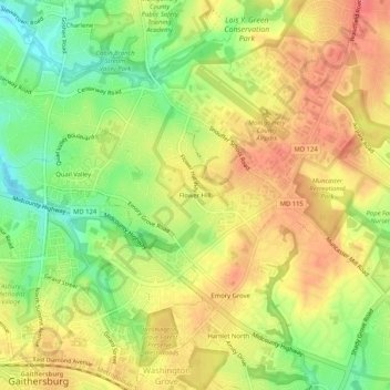
Name: Flower Hill topographic map, elevation, terrain.
Average elevation: 147 m
Minimum elevation: 110 m
Maximum elevation: 176 m
Other topographic maps
Click on a map to view its topography, its elevation and its terrain.
Lake Needwood
United States > Maryland > Montgomery County > Redland > Avery
Lake Needwood, Avery, Redland, Montgomery County, Maryland, United States
Average elevation: 122 m
Redland
United States > Maryland > Montgomery County > Redland
Redland, Montgomery County, Maryland, 20855, United States
Average elevation: 137 m