Geolocate

North Potomac topographic map

Interactive map

Click on the map to display elevation.

About this map

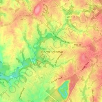
Name: North Potomac topographic map, elevation, terrain.

Location: North Potomac, Montgomery County, Maryland, United States (39.07841 -77.26774 39.11850 -77.19406)

Average elevation: 116 m

Minimum elevation: 64 m

Maximum elevation: 154 m

Between the 1990 and 2000 census, North Potomac gained and lost land. The loss was caused when a portion of the North Potomac territory, plus Potomac territory, was used to create the Travilah census designated place. According to the United States Census Bureau, North Potomac has a total area of 6.6 square miles (17 km2), virtually all land. The Muddy Branch and its tributary Rich Branch are streams that run through North Potomac, and the Muddy Branch empties into the Potomac River. The United States Geological Survey lists two features in Montgomery County with North Potomac in all or part of their name. The North Potomac Census Designated Place is listed with an elevation of 390 feet (120 m), while the North Potomac Populated Place has an elevation of 256 feet (78 m).

Wikipedia (CC-BY-SA 3.0)

Other topographic maps

Click on a map to view its topography, its elevation and its terrain.

Silver Spring

United States > Maryland > Montgomery County > Silver Spring

Silver Spring, Montgomery County, Maryland, United States

Average elevation: 86 m

Gaithersburg

United States > Maryland > Montgomery County

Gaithersburg, Montgomery County, Maryland, United States

Average elevation: 137 m

Laytonsville

United States > Maryland > Montgomery County

Laytonsville, Montgomery County, Maryland, United States

Average elevation: 172 m

Damascus

United States > Maryland > Montgomery County

Damascus, Montgomery County, Maryland, 20872, United States

Average elevation: 204 m

Clarksburg

United States > Maryland > Montgomery County

Clarksburg, Montgomery County, Maryland, United States

Average elevation: 166 m

White Oak

United States > Maryland > Montgomery County

White Oak, Montgomery County, Maryland, 20904, United States

Average elevation: 96 m

Montgomery Village

United States > Maryland > Montgomery County

Montgomery Village, Montgomery County, Maryland, 20886, United States

Average elevation: 139 m

Kemp Mill

United States > Maryland > Montgomery County

Kemp Mill, Montgomery County, Maryland, 20901, United States

Average elevation: 104 m

Flower Hill

United States > Maryland > Montgomery County > Redland

Flower Hill, Redland, Montgomery County, Maryland, 20879, United States

Average elevation: 147 m

Fairland

United States > Maryland > Montgomery County

Fairland, Montgomery County, Maryland, United States

Average elevation: 111 m

Quail Ridge

United States > Maryland > Montgomery County > Montgomery Village

Quail Ridge, Montgomery Village, Montgomery County, Maryland, 20876, United States

Average elevation: 133 m

Cabin John

United States > Maryland > Montgomery County

Cabin John, Montgomery County, Maryland, 20818, United States

Average elevation: 48 m

Chevy Chase Village

United States > Maryland > Montgomery County

Chevy Chase Village, Montgomery County, Maryland, United States

Average elevation: 99 m

Layhill

United States > Maryland > Montgomery County

Layhill, Montgomery County, Maryland, 20906, United States

Average elevation: 116 m

Glenmont

United States > Maryland > Montgomery County

Glenmont, Montgomery County, Maryland, 20902, United States

Average elevation: 109 m

Redland

United States > Maryland > Montgomery County

Redland, Montgomery County, Maryland, 20855, United States

Average elevation: 139 m

Cloverly

United States > Maryland > Montgomery County

Cloverly, Montgomery County, Maryland, 20905, United States

Average elevation: 139 m

Dickerson

United States > Maryland > Montgomery County

Dickerson, Montgomery County, Maryland, 20842, United States

Average elevation: 111 m

Glen Echo

United States > Maryland > Montgomery County

Glen Echo, Montgomery County, Maryland, 20812, United States

Average elevation: 55 m

Colesville

United States > Maryland > Montgomery County

Colesville, Montgomery County, Maryland, 20904, United States

Average elevation: 117 m

Aspen Hill

United States > Maryland > Montgomery County

Aspen Hill, Montgomery County, Maryland, 20906, United States

Average elevation: 114 m

Colesville

United States > Maryland > Montgomery County > Colesville

Colesville, Montgomery County, Maryland, 20904, United States

Average elevation: 113 m

Woodstock Equestrian Park

United States > Maryland > Montgomery County

Woodstock Equestrian Park, 20207, Montgomery County, Maryland, 20842, United States

Average elevation: 124 m

Germantown

United States > Maryland > Montgomery County

Germantown, Montgomery County, Maryland, 20874, United States

Average elevation: 136 m

Patuxent River State Park

United States > Maryland > Montgomery County

Patuxent River State Park, Montgomery County, Maryland, United States

Average elevation: 169 m

Darnestown

United States > Maryland > Montgomery County

Darnestown, Montgomery County, Maryland, United States

Average elevation: 97 m

Deerfield

United States > Maryland > Montgomery County > Potomac

Deerfield, Potomac, Montgomery County, Maryland, 20817, United States

Average elevation: 84 m

South Kensington

United States > Maryland > Montgomery County

South Kensington, Montgomery County, Maryland, United States

Average elevation: 92 m

Kemp Mill Estates

United States > Maryland > Montgomery County > Kemp Mill

Kemp Mill Estates, Kemp Mill, Montgomery County, Maryland, 20902, United States

Average elevation: 107 m

Farmlands

United States > Maryland > Montgomery County > Travilah

Farmlands, Travilah, Montgomery County, Maryland, United States

Average elevation: 93 m

Damascus

United States > Maryland > Montgomery County > Damascus

Damascus, Montgomery County, Maryland, 20872, United States

Average elevation: 195 m

Germantown

United States > Maryland > Montgomery County > Germantown

Germantown, Montgomery County, Maryland, United States

Average elevation: 130 m

Garrett Park

United States > Maryland > Montgomery County

Garrett Park, Montgomery County, Maryland, 20896, United States

Average elevation: 90 m

Chevy Chase View

United States > Maryland > Montgomery County

Chevy Chase View, Montgomery County, Maryland, United States

Average elevation: 82 m

Hunting Hill

United States > Maryland > Montgomery County > Rockville

Hunting Hill, Rockville, Montgomery County, Maryland, 20850, United States

Average elevation: 127 m

Olney

United States > Maryland > Montgomery County

Olney, Montgomery County, Maryland, United States

Average elevation: 136 m

Norbeck

United States > Maryland > Montgomery County > Olney

Norbeck, Olney, Montgomery County, Maryland, 20853, United States

Average elevation: 134 m

Lake Needwood

United States > Maryland > Montgomery County > Redland > Avery

Lake Needwood, Avery, Redland, Montgomery County, Maryland, United States

Average elevation: 122 m

Chevy Chase

United States > Maryland > Montgomery County

Chevy Chase, Montgomery County, Maryland, 20815, United States

Average elevation: 99 m

Bethesda

United States > Maryland > Montgomery County

Bethesda, Montgomery County, Maryland, United States

Average elevation: 81 m

Seneca

United States > Maryland > Montgomery County > Darnestown

Seneca, Darnestown, Montgomery County, Maryland, United States

Average elevation: 82 m

White Oak

United States > Maryland > Montgomery County > White Oak

White Oak, Montgomery County, Maryland, 20993, United States

Average elevation: 101 m

Rockville

United States > Maryland > Montgomery County

Rockville, Montgomery County, Maryland, United States

Average elevation: 122 m

Great Falls

United States > Maryland > Montgomery County > Potomac

Great Falls, Potomac, Montgomery County, Maryland, United States

Average elevation: 73 m

Orchard Place

United States > Maryland > Montgomery County > Gaithersburg

Orchard Place, Gaithersburg, Montgomery County, Maryland, 20899, United States

Average elevation: 128 m

Washington Grove

United States > Maryland > Montgomery County

Washington Grove, Montgomery County, Maryland, 20880, United States

Average elevation: 150 m

Sandy Spring

United States > Maryland > Montgomery County

Sandy Spring, Montgomery County, Maryland, 20860, United States

Average elevation: 137 m

Campbell Corner

United States > Maryland > Montgomery County > Potomac

Campbell Corner, Potomac, Montgomery County, Maryland, 20818, United States

Average elevation: 82 m

Derwood

United States > Maryland > Montgomery County

Derwood, Montgomery County, Maryland, 20855, United States

Average elevation: 133 m

Montgomery Village

United States > Maryland > Montgomery County > Montgomery Village

Montgomery Village, Montgomery County, Maryland, 20886, United States

Average elevation: 132 m