
Make a donation
South Cotabato topographic map
Click on the map to display elevation.
Make a donation
South Cotabato
Maximum daytime temperature throughout the province is in the range of 36 to 38 °C (97 to 100 °F), falling to 23 to 32 °C (73 to 90 °F) during the night depending on the elevation. The hottest period is January to April while July to December being the coolest.
Make a donation
About this map
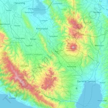
Name: South Cotabato topographic map, elevation, terrain.
Location: South Cotabato, Soccsksargen, Philippines (5.96145 124.39097 6.66302 125.18962)
Average elevation: 414 m
Minimum elevation: 0 m
Maximum elevation: 2,241 m
Make a donation
Other topographic maps
Click on a map to view its topography, its elevation and its terrain.
Make a donation
Mount Mayon
Philippines > Albay > Tabaco
On February 23, 2023, a twin engine Cessna 340 airplane owned by the Energy Development Corporation departed Bicol International Airport in the early morning on an executive flight to the capital Manila. A few minutes after takeoff, while climbing to an altitude of 6,000 ft (1,800 m), it impacted the rocky…
Average elevation: 1,696 m
Make a donation
Make a donation
Make a donation
Make a donation
Make a donation
Make a donation