
Thank you for supporting this site ❤️
Make a donation
Make a donation
New Valley topographic map
Click on the map to display elevation.
Thank you for supporting this site ❤️
Make a donation
Make a donation
About this map
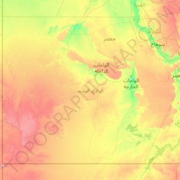
Name: New Valley topographic map, elevation, terrain.
Location: New Valley, Egypt (22.00000 24.99694 27.74891 32.74019)
Average elevation: 348 m
Minimum elevation: 7 m
Maximum elevation: 1,881 m
Thank you for supporting this site ❤️
Make a donation
Make a donation
Other topographic maps
Click on a map to view its topography, its elevation and its terrain.
Thank you for supporting this site ❤️
Make a donation
Make a donation
Thank you for supporting this site ❤️
Make a donation
Make a donation
Thank you for supporting this site ❤️
Make a donation
Make a donation