Geolocate

重华镇 topographic map

Interactive map

Click on the map to display elevation.

About this map

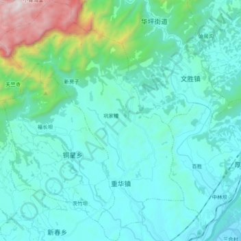
Name: 重华镇 topographic map, elevation, terrain.

Location: 重华镇, 江油市, 绵阳市, 四川省, 中国 (31.92466 104.89767 32.06132 105.02167)

Average elevation: 811 m

Minimum elevation: 547 m

Maximum elevation: 2,312 m

Other topographic maps

Click on a map to view its topography, its elevation and its terrain.

武都镇

中国 > 四川省 > 江油市 > 绵阳市

武都镇, 江油市, 绵阳市, 四川省, 中国

Average elevation: 684 m

枫顺乡

中国 > 四川省 > 江油市 > 绵阳市

枫顺乡, 江油市, 绵阳市, 四川省, 中国

Average elevation: 1,294 m

青莲镇

中国 > 四川省 > 江油市 > 绵阳市

青莲镇, 江油市, 绵阳市, 四川省, 中国

Average elevation: 522 m

厚坝镇

中国 > 四川省 > 江油市 > 绵阳市

厚坝镇, 江油市, 绵阳市, 四川省, 621715, 中国

Average elevation: 655 m

八一镇

中国 > 四川省 > 江油市 > 绵阳市

八一镇, 江油市, 绵阳市, 四川省, 中国

Average elevation: 609 m