
Thank you for supporting this site ❤️
Make a donation
Make a donation
Navotas topographic map
Click on the map to display elevation.
Thank you for supporting this site ❤️
Make a donation
Make a donation
About this map
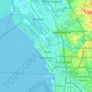
Name: Navotas topographic map, elevation, terrain.
Location: Navotas, Northern Manila District, Metro Manila, Philippines (14.63380 120.83949 14.71285 120.96910)
Average elevation: 7 m
Minimum elevation: -4 m
Maximum elevation: 54 m
Thank you for supporting this site ❤️
Make a donation
Make a donation
Other topographic maps
Click on a map to view its topography, its elevation and its terrain.
Thank you for supporting this site ❤️
Make a donation
Make a donation
Mount Mayon
Philippines > Albay > Tabaco
On February 23, 2023, a twin engine Cessna 340 airplane owned by the Energy Development Corporation departed Bicol International Airport in the early morning on an executive flight to the capital Manila. A few minutes after takeoff, while climbing to an altitude of 6,000 ft (1,800 m), it impacted the rocky…
Average elevation: 1,696 m
Thank you for supporting this site ❤️
Make a donation
Make a donation
Thank you for supporting this site ❤️
Make a donation
Make a donation
Thank you for supporting this site ❤️
Make a donation
Make a donation
Thank you for supporting this site ❤️
Make a donation
Make a donation
Thank you for supporting this site ❤️
Make a donation
Make a donation
Thank you for supporting this site ❤️
Make a donation
Make a donation