
Thank you for supporting this site ❤️
Make a donation
Make a donation
Mae Sai district topographic map
Click on the map to display elevation.
Thank you for supporting this site ❤️
Make a donation
Make a donation
About this map
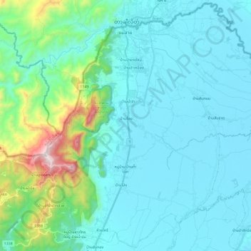
Name: Mae Sai district topographic map, elevation, terrain.
Average elevation: 525 m
Minimum elevation: 365 m
Maximum elevation: 1,472 m
Thank you for supporting this site ❤️
Make a donation
Make a donation
Other topographic maps
Click on a map to view its topography, its elevation and its terrain.
Mae Salong
Thailand > Chiang Rai Province > Mae Fa Luang district
Santikhiri is a hilltop village in the Mae Fa Luang district of Thailand's Chiang Rai Province, about 80 kilometres (50 mi) from Chiang Rai. Santikhiri is on the highest peak of the Doi Mae Salong range of mountains, at an elevation of 1,134 metres (3,722 ft) above sea level. It has an alpine-like climate,…
Average elevation: 1,035 m