
Tankersley topographic map
Interactive map
Click on the map to display elevation.
About this map
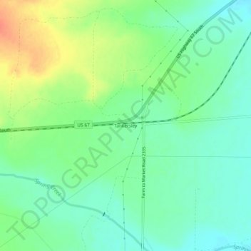
Name: Tankersley topographic map, elevation, terrain.
Location: Tankersley, Tom Green County, Texas, United States (31.32961 -100.66343 31.36961 -100.62343)
Average elevation: 614 m
Minimum elevation: 597 m
Maximum elevation: 644 m
Other topographic maps
Click on a map to view its topography, its elevation and its terrain.
San Angelo
United States > Texas > Tom Green County
San Angelo, Tom Green County, Texas, United States
Average elevation: 576 m
Lake Nasworthy
United States > Texas > Tom Green County > San Angelo
Lake Nasworthy, San Angelo, Tom Green County, Texas, United States
Average elevation: 578 m
Knickerbocker
United States > Texas > Tom Green County
Knickerbocker, Tom Green County, Texas, 76939, United States
Average elevation: 634 m
Wall
United States > Texas > Tom Green County
Wall, Tom Green County, Texas, 76957, United States
Average elevation: 569 m
Christoval
United States > Texas > Tom Green County
Christoval, Tom Green County, Texas, 76935, United States
Average elevation: 643 m
Water Valley
United States > Texas > Tom Green County
Water Valley, Tom Green County, Texas, 76958, United States
Average elevation: 650 m
San Angelo
United States > Texas > Tom Green County > San Angelo
San Angelo, Tom Green County, Texas, 76903, United States
Average elevation: 588 m