
Make a donation
Manila topographic map
Click on the map to display elevation.
Make a donation
Manila
Almost all of Manila sits on top prehistoric alluvial deposits built by the waters of the Pasig River and on land reclaimed from Manila Bay. Manila's land has been substantially altered by human intervention; there has been considerable land reclamation along the waterfronts since the early-to-mid twentieth century. Some of the city's natural variations in topography have been leveled. As of 2013, Manila had a total area of 42.88 square kilometres (16.56 sq mi).
Make a donation
About this map
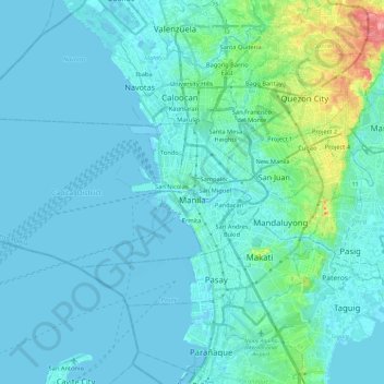
Name: Manila topographic map, elevation, terrain.
Location: Manila, Capital District, Metro Manila, Philippines (14.55082 120.79170 14.63955 121.02617)
Average elevation: 12 m
Minimum elevation: -3 m
Maximum elevation: 106 m
Make a donation
Other topographic maps
Click on a map to view its topography, its elevation and its terrain.
Make a donation
Mount Mayon
Philippines > Albay > Tabaco
On February 23, 2023, a twin engine Cessna 340 airplane owned by the Energy Development Corporation departed Bicol International Airport in the early morning on an executive flight to the capital Manila. A few minutes after takeoff, while climbing to an altitude of 6,000 ft (1,800 m), it impacted the rocky…
Average elevation: 1,696 m
Make a donation
Make a donation
Make a donation
Make a donation
Make a donation
Make a donation