
连云港市 topographic map
Interactive map
Click on the map to display elevation.
About this map
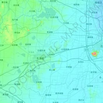
Name: 连云港市 topographic map, elevation, terrain.
Location: 连云港市, 东海县, 江苏省, 中国 (34.31440 118.39555 34.80513 119.11255)
Average elevation: 22 m
Minimum elevation: -2 m
Maximum elevation: 421 m
境内山脉主要属于沂蒙山的余脉,绵亘近300公里。有大小山峰214座,主要有南云台山、中云台山、北云台山、锦屏山、马陵山、羽山、夹山、大伊山等。南云台山之玉女峰,海拔624.4米,也是江苏省的最高点。
Other topographic maps
Click on a map to view its topography, its elevation and its terrain.