Geolocate

松顶 topographic map

Interactive map

Click on the map to display elevation.

About this map

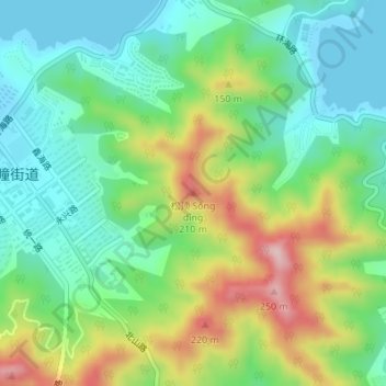
Name: 松顶 topographic map, elevation, terrain.

Location: 松顶, 威海市, 环翠区, 威海市, 山东省, 264200, 中国 (37.53829 122.12496 37.53839 122.12506)

Average elevation: 97 m

Minimum elevation: -1 m

Maximum elevation: 282 m

Other topographic maps

Click on a map to view its topography, its elevation and its terrain.

威海市

中国 > 山东省 > 威海市

威海市, 环翠区, 威海市, 山东省, 264200, 中国

Average elevation: 25 m

烟墩角村

中国 > 山东省 > 威海市

烟墩角村, 威海市, 山东省, 264200, 中国

Average elevation: 8 m

界石镇

中国 > 山东省 > 威海市

界石镇, 威海市, 山东省, 264200, 中国

Average elevation: 80 m

紫金山

中国 > 山东省 > 威海市

紫金山, 威海市, 山东省, 264200, 中国

Average elevation: 131 m

徐家疃村

中国 > 山东省 > 威海市 > 徐家疃村

徐家疃村, 威海市, 山东省, 264200, 中国

Average elevation: 50 m