
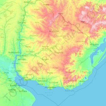
Uruguay topographic map
Interactive map
Click on the map to display elevation.
About this map
Name: Uruguay topographic map, elevation, terrain.
Location: Uruguay (-35.78248 -58.49477 -30.08540 -53.07558)
Average elevation: 83 m
Minimum elevation: -4 m
Maximum elevation: 485 m
The country experiences four seasons, with summer from December to March and winter from June to September. Seasonal variations are pronounced, but extremes in temperature are rare. Summers are tempered by winds off the Atlantic, and severe cold in winter is unknown. Although it never gets too cold, frosts occur every year during the winter months, and precipitation such as sleet and hail occur almost every winter, but snow is very rare; it does occur every couple of years at higher elevations, but almost always without accumulation. As would be expected with its abundance of water, high humidity and fog are common.
Other topographic maps
Click on a map to view its topography, its elevation and its terrain.
Kharkiv
Kharkiv, Kharkiv Urban Hromada, Kharkiv Raion, Kharkiv Oblast, Ukraine
Average elevation: 146 m
Dniprorudne
Dniprorudne, Dniprorudnenska urban hromada, Vasylivka Raion, Zaporizhia Oblast, 71630, Ukraine
Average elevation: 64 m
Chiang Mai
Thailand > Chiang Mai Province
Chiang Mai, Pa Daet, Saraphi District, Chiang Mai Province, 55520, Thailand
Average elevation: 424 m
Upper East Side
USA > New York > New York City
Upper East Side, Manhattan, Manhattan Community Board 8, New York County, New York City, New York, USA
Average elevation: 27 m
Kuban
Kuban, Bilolutska settlement hromada, Starobilsk Raion, Luhansk Oblast, 92326, Ukraine
Average elevation: 83 m
Okinawa Prefecture
Japan > Kyushu Region > Nago
Okinawa Prefecture, 県道18号, Nago, Okinawa Prefecture, Kyushu Region, 905-2266, Japan
Average elevation: 139 m
Yiling Cave
Yiling Cave, 南武大道, Yiling Industrial Concentration Zone, Wuming District, Nanning, Guangxi, China
Average elevation: 140 m
Chasiv Yar
Chasiv Yar, Chasiv Yar urban hromada, Bakhmut Raion, Donetsk Oblast, 84551-84556, Ukraine
Average elevation: 213 m
Kocatepe
Kocatepe, Afyonkarahisar, Aegean Region, Turkey
Average elevation: 1,437 m
Jersey City
United States > New Jersey > Hudson County
Jersey City, Hudson County, New Jersey, United States
Average elevation: 9 m
Yangshuo County
Yangshuo County, Guilin, Guangxi, China
Average elevation: 319 m
Schladming
Austria > Styria > Bezirk Liezen
Schladming, Politische Expositur Gröbming, Bezirk Liezen, Styria, 8970, Austria
Average elevation: 1,552 m
Saint-Martin-de-Ré
France > Nouvelle-Aquitaine > Charente-Maritime
Saint-Martin-de-Ré, La Rochelle, Charente-Maritime, Nouvelle-Aquitaine, Metropolitan France, 17410, France
Average elevation: 6 m
Avdiivka
Avdiivka, Avdiivka urban hromada, Pokrovskii Raion, Donetsk Oblast, 86060-86075, Ukraine
Average elevation: 206 m
Ascain
France > Nouvelle-Aquitaine > Pyrénées-Atlantiques
Ascain, Bayonne, Pyrénées-Atlantiques, Nouvelle-Aquitaine, Metropolitan France, 64310, France
Average elevation: 169 m
Dongguang County
Dongguang County, Cangzhou, Hebei, 061600, China
Average elevation: 14 m
Dominican Republic
Dominican Republic
Average elevation: 126 m
La Flotte
France > Nouvelle-Aquitaine > Charente-Maritime
La Flotte, La Rochelle, Charente-Maritime, Nouvelle-Aquitaine, Metropolitan France, 17630, France
Average elevation: 7 m
Nam Tin
China > Hong Kong > Islands District > Tai O
Nam Tin, Tai O, Islands District, New Territories, Hong Kong, China
Average elevation: 146 m
Buck Lake
Canada > Alberta > County of Wetaskiwin
Buck Lake, County of Wetaskiwin, Alberta, T0C 0T0, Canada
Average elevation: 901 m
Sai Kung District
Sai Kung District, New Territories, Hong Kong, China
Average elevation: 29 m
Nam Tin
Myanmar > Shan State > Mongpauk County
Nam Tin, Mongpauk District, Mongpauk County, East Shan State, Shan State, Wa State, Myanmar
Average elevation: 1,409 m
Bishop's Stortford
United Kingdom > England > Hertfordshire > East Hertfordshire
Bishop's Stortford, East Hertfordshire, Hertfordshire, England, United Kingdom
Average elevation: 83 m
Cheadle
United Kingdom > England > Staffordshire > Staffordshire Moorlands
Cheadle, Staffordshire Moorlands, Staffordshire, England, United Kingdom
Average elevation: 191 m
Sunnyvale
United States > California > Santa Clara County
Sunnyvale, Santa Clara County, California, United States
Average elevation: 24 m
Kalgo
Nigeria > Sokoto State > Sabon Birni
Kalgo, Sabon Birni, Sokoto State, Nigeria
Average elevation: 325 m
Daocheng County
Daocheng County, Kardze, Sichuan, 627700, China
Average elevation: 3,926 m
Quezon City
Quezon City, Eastern Manila District, Metro Manila, Philippines
Average elevation: 39 m
Buôn Ma Thuột
Buôn Ma Thuột, Đắk Lắk Province, Vietnam
Average elevation: 442 m
Devil Lake
United States > Oregon > Klamath County
Devil Lake, Klamath County, Oregon, United States
Average elevation: 1,474 m
Dầu Tiếng District
Dầu Tiếng District, Bình Dương Province, Vietnam
Average elevation: 31 m
Phú Giáo District
Phú Giáo District, Bình Dương Province, Vietnam
Average elevation: 55 m
Rottenburg am Neckar
Germany > Baden-Württemberg > Landkreis Tübingen
Rottenburg am Neckar, Verwaltungsgemeinschaft Rottenburg am Neckar, Landkreis Tübingen, Baden-Württemberg, 72108, Germany
Average elevation: 414 m