
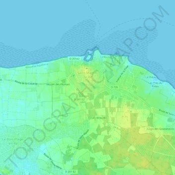
Saint-Martin-de-Ré topographic map
Interactive map
Click on the map to display elevation.
About this map
Name: Saint-Martin-de-Ré topographic map, elevation, terrain.
Average elevation: 6 m
Minimum elevation: -1 m
Maximum elevation: 16 m
Other topographic maps
Click on a map to view its topography, its elevation and its terrain.
La Flotte
France > Nouvelle-Aquitaine > Charente-Maritime
La Flotte, La Rochelle, Charente-Maritime, Nouvelle-Aquitaine, Metropolitan France, 17630, France
Average elevation: 7 m