
Adana topographic map
Click on the map to display elevation.
Adana
Aladağlar National Park, located north of Adana, is a huge park of around 55,000 hectares, the summit of Demirkazik at 3756m is the highest point in the middle Taurus mountain range. There is a huge range of flora and fauna, and visitors may fish in the streams full of trout. Wildlife includes wild goats, bears, lynx and sable. The most common species of plant life is black pine and cluster pine trees, with some cedar dotted between, and fir trees in the northern areas with higher humidity. The Alpine region, from the upper borders of the forest, has pastures with rocky areas and little variety of plant life because of the high altitude and slope.
About this map
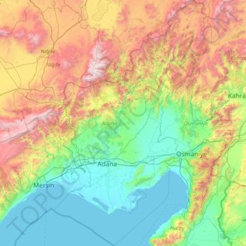
Name: Adana topographic map, elevation, terrain.
Location: Adana, Mediterranean Region, Turkey (36.26304 34.73930 38.40460 36.40958)
Average elevation: 879 m
Minimum elevation: -2 m
Maximum elevation: 3,603 m
Other topographic maps
Click on a map to view its topography, its elevation and its terrain.
Gaziantep
The plan introduced several important changes to the city's transportation network. One of the most important was the addition of a rail line to connect Gaziantep to the national rail system. Up to now, Turkish railway construction had ignored Gaziantep (partly because of its mountainous surroundings); a…
Average elevation: 880 m
Marash
Turkey > Dulkadiroğlu > Dulkadiroğlu
At 2,300 m (7,500 ft) elevation, the nearby Yedikuyular Ski Resort offers winter sports activities.[25]
Average elevation: 843 m
Mount Erciyes
The climate of the region is influenced by topography, with the Taurus and Kaçkar Mountains blocking the entry of moisture into Anatolia. Summers are dry and hot and winters wet and cold; in Kayseri, summer temperatures are about 19 °C (66 °F) and winter temperature about 0 °C (32 °F). Precipitation at…
Average elevation: 3,329 m