
Uttar Pradesh topographic map
Interactive map
Click on the map to display elevation.
About this map
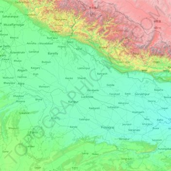
Name: Uttar Pradesh topographic map, elevation, terrain.
Location: Uttar Pradesh, India (23.87255 77.08507 30.41242 84.63069)
Average elevation: 955 m
Minimum elevation: 46 m
Maximum elevation: 7,878 m
Other topographic maps
Click on a map to view its topography, its elevation and its terrain.
Mountains
Mountains, Kānpur, Kanpur Dehat, Uttar Pradesh, India
Average elevation: 135 m
Jhansi
India > Uttar Pradesh > Jhansi
Jhansi, Jhānsi, Jhansi, Uttar Pradesh, 284001, India
Average elevation: 237 m