
Make a donation
Afyonkarahisar topographic map
Click on the map to display elevation.
Make a donation
About this map
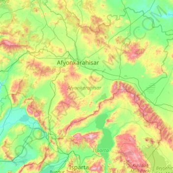
Name: Afyonkarahisar topographic map, elevation, terrain.
Location: Afyonkarahisar, Aegean Region, Turkey (37.77749 29.65889 39.27085 31.73199)
Average elevation: 1,202 m
Minimum elevation: 798 m
Maximum elevation: 2,734 m
Make a donation
Other topographic maps
Click on a map to view its topography, its elevation and its terrain.
Istanbul
Istanbul, located in northwestern Turkey, is a city that is uniquely situated across two continents, Europe and Asia, divided by the Bosphorus Strait. The city’s topography is characterized by a complex blend of hills, valleys, and coastal plains, which create a varied and scenic landscape. The European side…
Average elevation: 57 m
Antalya
While the city itself only has modest elevation changes, Antalya has high mountains in all directions to its interior. With moisture being trapped, the local climate thus has high winter rainfall, while the interior bay setting result in very hot summers for a coastal city.
Average elevation: 117 m
Istanbul
Istanbul, located in northwestern Turkey, is a city that is uniquely situated across two continents, Europe and Asia, divided by the Bosphorus Strait. The city’s topography is characterized by a complex blend of hills, valleys, and coastal plains, which create a varied and scenic landscape. The European side…
Average elevation: 57 m
Make a donation
Ankara
Ankara has a cold semi-arid climate (Köppen climate classification: BSk). Under the Trewartha climate classification, Ankara has a temperate humid continental climate (Dc). Due to its elevation and inland location, Ankara has cold and snowy winters, and hot and dry summers. Rainfall occurs mostly during the…
Average elevation: 1,082 m
Taurus Mountains
The mountains have a Mediterranean climate, with dry summers and rainy winters. Temperatures vary with elevation, with warm winters on the lower coastal slopes and cold winters in the high mountains and in the interior.
Average elevation: 828 m
Make a donation
Ankara
Ankara has a cold semi-arid climate (Köppen climate classification: BSk). Under the Trewartha climate classification, Ankara has a temperate humid continental climate (Dc). Due to its elevation and inland location, Ankara has cold and snowy winters, and hot and dry summers. Rainfall occurs mostly during the…
Average elevation: 1,082 m
Make a donation
Make a donation
Make a donation
Make a donation
Make a donation
Make a donation
Istanbul
Istanbul, located in northwestern Turkey, is a city that is uniquely situated across two continents, Europe and Asia, divided by the Bosphorus Strait. The city’s topography is characterized by a complex blend of hills, valleys, and coastal plains, which create a varied and scenic landscape. The European side…
Average elevation: 57 m
Make a donation
Mount Tahtali
Tahtalı Dağı lies on the east coast of the Teke Peninsula (Lycian Peninsula), dominating the landscape around Kemer. Located between Antalya and Finike and the dominant peak of the mountain range Bey Dağları (Turkish: Bey Mountains). From it, the start of the Taurus Mountains can be seen. Its close…
Average elevation: 1,790 m
Make a donation
Make a donation
Make a donation
Make a donation
Gölcük Gölü
It is a lake hosted in a maar whose rim is 150 to 300 m high from the water surface. The lake is located at an altitude of 1380 m, has an area of 105 hectares, a width of 2.5 km, and a depth of 32 m. It is fed by springs at the bottom of the lake and by rainwater. The lake's water is fresh. For a while, the…
Average elevation: 1,442 m
Beycik
Beycik is situated in the Olympos National Park, in the foothills of Mount Olympos (2,400 m) and at an altitude of 450 m to 1,000 m. Noteworthy tourist attractions in the vicinity are Phaselis and Tekirova. The distance to the city of Antalya is 65 km and to the tourist town of Kemer is 22 km.
Average elevation: 995 m
Make a donation
Kaçkar Dağı
Mount Kaçkar (Turkish: Kaçkar Dağı), with an elevation of 3,937 meters, is the highest peak in the Kaçkar Mountains. The mountain may be climbed by the northeast ridge route beginning from the village Yukarı Kavrun.
Average elevation: 3,388 m
Make a donation
Kayseri
Kayseri sits at the foot of Mount Erciyes (Turkish: Erciyes Dağı), a dormant volcano that reaches an altitude of 3,917 metres (12,851 feet), more than 1,500 metres above the city's mean altitude. It contains a number of historic monuments, particularly from the Seljuk period. Tourists often pass through…
Average elevation: 1,345 m
Make a donation
Make a donation
Mount Ararat
Mount Ararat, officially Mount Ağrı, or also known as Masis is a snow- capped and dormant compound volcano in easternmost Turkey. It consists of two major volcanic cones: Greater Ararat and Little Ararat. Greater Ararat is the highest peak in Turkey and the Armenian highlands with an elevation of 5,137 m…
Average elevation: 4,582 m
Make a donation
Gaziantep
The plan introduced several important changes to the city's transportation network. One of the most important was the addition of a rail line to connect Gaziantep to the national rail system. Up to now, Turkish railway construction had ignored Gaziantep (partly because of its mountainous surroundings); a…
Average elevation: 880 m
Make a donation
Make a donation
Make a donation
Make a donation
Make a donation
Make a donation
Make a donation