
Death Valley National Park topographic map
Interactive map
Click on the map to display elevation.
Death Valley National Park
Death Valley's Badwater Basin is the point of lowest elevation in North America, at 282 feet (86 m) below sea level. It is 84.6 miles (136.2 km) east-southeast of Mount Whitney, the highest point in the contiguous United States, with an elevation of 14,505 feet (4,421 m). On the afternoon of July 10, 1913, the United States Weather Bureau recorded a high temperature of 134 °F (56.7 °C) at Furnace Creek in Death Valley, which stands as the highest ambient air temperature ever recorded at the surface of the Earth. This reading, however, and several others taken in that period, a century ago, are in dispute by some modern experts.
About this map
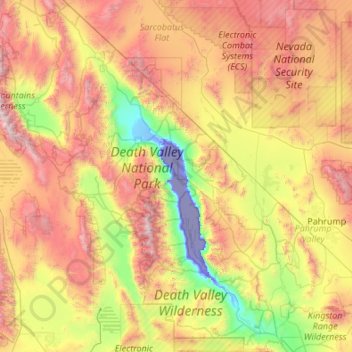
Name: Death Valley National Park topographic map, elevation, terrain.
Average elevation: 1,085 m
Minimum elevation: -83 m
Maximum elevation: 3,329 m
Other topographic maps
Click on a map to view its topography, its elevation and its terrain.
Cajon Pass
United States > California > San Bernardino County
Cajon Pass (/kəˈhoʊn/; Spanish: Puerto del Cajón or Paso del Cajón) is a mountain pass between the San Bernardino Mountains to the east and the San Gabriel Mountains to the west in Southern California. Created by the movements of the San Andreas Fault, it has an elevation of 3,777 ft (1,151 m). Located in…
Average elevation: 1,169 m
Bowles
United States > California > Fresno County
Bowles is a census-designated place (CDP) in Fresno County, California, United States. The population was 166 at the 2010 census, down from 182 at the 2000 census. Bowles is located 11 miles (18 km) south of downtown Fresno, at an elevation of 279 feet (85 m).
Average elevation: 86 m
Brentwood
United States > California > Contra Costa County > Brentwood > Brentwood
Average elevation: 27 m