
Death Valley National Park topographic map
Interactive map
Click on the map to display elevation.
About this map
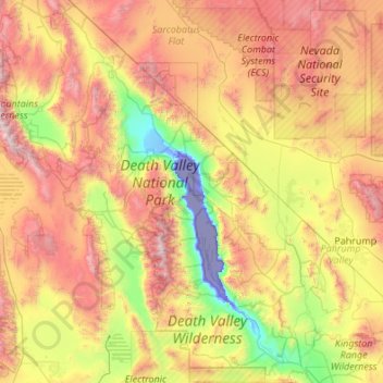
Name: Death Valley National Park topographic map, elevation, terrain.
Average elevation: 1,085 m
Minimum elevation: -83 m
Maximum elevation: 3,329 m
Death Valley's Badwater Basin is the point of lowest elevation in North America, at 282 feet (86 m) below sea level. It is 84.6 miles (136.2 km) east-southeast of Mount Whitney, the highest point in the contiguous United States, with an elevation of 14,505 feet (4,421 m). On the afternoon of July 10, 1913, the United States Weather Bureau recorded a high temperature of 134 °F (56.7 °C) at Furnace Creek in Death Valley, which stands as the highest ambient air temperature ever recorded at the surface of the Earth. This reading, however, and several others taken in that period, a century ago, are in dispute by some modern experts.
Other topographic maps
Click on a map to view its topography, its elevation and its terrain.
Bowles
United States > California > Fresno County
Bowles, Fresno County, California, United States
Average elevation: 86 m
Cajon Pass
United States > California > San Bernardino County
Cajon Pass, San Bernardino County, California, United States
Average elevation: 1,169 m
Berkeley
United States > California > Alameda County
Berkeley, Alameda County, California, United States
Average elevation: 109 m
Tehachapi
United States > California > Kern County
Tehachapi, Kern County, California, United States
Average elevation: 1,414 m
San Francisco
San Francisco, California, United States
Average elevation: 63 m
South
United States > California > Los Angeles County
South, Los Angeles County, California, 90704, United States
Average elevation: 130 m
Redwood City
United States > California > San Mateo County
Redwood City, San Mateo County, California, United States
Average elevation: 32 m
Irvine
United States > California > Orange County
Irvine, Orange County, CAL Fire Southern Region, California, United States
Average elevation: 66 m
Aliso Viejo
United States > California > Orange County
Aliso Viejo, Orange County, CAL Fire Southern Region, California, 92656, United States
Average elevation: 127 m
Modesto
United States > California > Stanislaus County
Modesto, Stanislaus County, CAL Fire Southern Region, California, United States
Average elevation: 26 m
Brentwood
United States > California > Contra Costa County > Brentwood > Brentwood
Brentwood, Contra Costa County, California, 94513, United States
Average elevation: 27 m
Volcano
United States > California > Volcano
Volcano, Amador County, California, 95689, United States
Average elevation: 726 m
Sierra County
Sierra County, California, United States
Average elevation: 1,690 m
Monterey County
Monterey County, California, United States
Average elevation: 283 m
Long Beach
United States > California > Long Beach
Long Beach, Los Angeles County, California, United States
Average elevation: 12 m