
Europe topographic map
Click on the map to display elevation.
Europe
Europe's topography is characterized by a striking contrast between its rugged southern mountains and the expansive plains of the north. The continent is often described as a "peninsula of peninsulas," featuring major peninsulas like the Iberian, Italian, and Balkan, each with unique geological features. In the southern regions, mountain ranges such as the Alps and the Pyrenees rise dramatically, with elevations frequently exceeding 9,800 feet (3,000 meters). Moving northward, the terrain gradually descends into the Great European Plain, a vast lowland stretching from the Pyrenees in the west to the Ural Mountains in the east, where most elevations are below 1,640 feet (500 meters). This plain is interspersed with rolling hills and valleys, making it one of the most agriculturally productive areas in Europe, while also being historically significant due to its accessibility for trade and invasion. The northern regions, including Scandinavia and the British Isles, are marked by fjords and rugged uplands, contributing to a diverse and complex landscape across the continent.
About this map
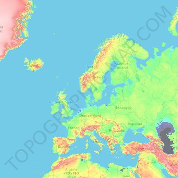
Name: Europe topographic map, elevation, terrain.
Location: Europe (26.00000 -15.00000 76.00000 35.00000)
Average elevation: 223 m
Minimum elevation: -30 m
Maximum elevation: 3,987 m
Other topographic maps
Click on a map to view its topography, its elevation and its terrain.
Pulau Bali
Bali's central mountains include several peaks over 2,000 metres (6,600 feet) in elevation and active volcanoes such as Mount Batur. The highest is Mount Agung (3,031 m; 9,944 ft), known as the "mother mountain", which is an active volcano rated as one of the world's most likely sites for a massive eruption…
Average elevation: 122 m
Norway
At 385,207 square kilometres (148,729 sq mi) (including Svalbard and Jan Mayen; 323,808 square kilometres (125,023 sq mi) without), much of the country is dominated by mountainous or high terrain, with a great variety of natural features caused by prehistoric glaciers and varied topography. The most noticeable…
Average elevation: 143 m
New Alresford
United Kingdom > England > Hampshire > Winchester > Bishop's Sutton
Average elevation: 83 m
Jerusalem
Jerusalem is situated on the southern spur of a plateau in the Judaean Mountains, which include the Mount of Olives (East) and Mount Scopus (North East). The elevation of the Old City is approximately 760 m (2,490 ft). The whole of Jerusalem is surrounded by valleys and dry riverbeds (wadis). The Kidron,…
Average elevation: 639 m
Bern
Switzerland > Bern > Bern-Mittelland administrative district
Bern is built on very uneven ground. An elevation difference of up to 60 metres exists between the inner city districts on the Aare (Matte, Marzili) and the higher ones (Kirchenfeld, Länggasse).
Average elevation: 612 m
Santa Catarina
It is one of the Brazilian states with the most mountainous terrain, where 52% of the territory is located above 600 metres. According to the Köppen-Geiger climate classification system, Santa Catarina predominantly features a humid subtropical climate (Cfa) in the coastal lowlands and the lower altitude…
Average elevation: 530 m
Sutton upon Derwent
United Kingdom > England > East Riding of Yorkshire > Sutton Upon Derwent
Average elevation: 10 m
Waterloo
United States > Iowa > Black Hawk County
The average elevation of Waterloo is 846 feet above sea level. The population density is 1101 people per square mile, considered low for an urban area.
Average elevation: 272 m
Selayang Municipal Council
Given its varied topography pattern and close proximity to the Titiwangsa Mountains (Banjaran Titiwangsa), Selayang is a mix of urban and countryside sceneries. Its premier natural attraction, which is well known across the country, is the Forest Research Institute Malaysia (FRIM), also known as FRIM Kepong.…
Average elevation: 236 m
Thailand
Thailand comprises several distinct geographic regions, partly corresponding to the provincial groups. The north of the country is the mountainous area of the Thai highlands, with the highest point being Doi Inthanon in the Thanon Thong Chai Range at 2,565 metres (8,415 ft) elevation. The northeast, Isan,…
Average elevation: 156 m
City of Cuzco
Cusco is the seventh-most populous city in Peru; in 2017, it had a population of 428,450. It is also the largest city in the Peruvian Andes and the region is the seventh-most populous metropolitan area of Peru. Its elevation is around 3,400 m (11,200 ft). The largest district in the city is the Cusco District,…
Average elevation: 3,453 m
Baguio
It is known as the "Summer Capital of the Philippines", owing to the city's cool climate relative to the lowlands. With an approximate elevation of 1,500 meters (4,900 feet) above mean sea level, Baguio belongs to the Luzon tropical pine forests ecoregion; the climate is conducive for the growth of mossy…
Average elevation: 1,371 m
Turkey
Turkey's topography is a diverse tapestry of mountains, plateaus, and coastal plains that create a strikingly varied landscape. The country is predominantly characterized by the Anatolian Plateau, a semi-arid highland that stretches across central Turkey, with elevations ranging from 700 to 2,000 meters. This…
Average elevation: 487 m
Norway
At 385,207 square kilometres (148,729 sq mi) (including Svalbard and Jan Mayen; 323,808 square kilometres (125,023 sq mi) without), much of the country is dominated by mountainous or high terrain, with a great variety of natural features caused by prehistoric glaciers and varied topography. The most noticeable…
Average elevation: 293 m
Greece
Greece's topography is predominantly mountainous, with approximately 80% of its terrain consisting of mountains or hills, making it one of the most mountainous countries in Europe. The Pindus mountain range, often referred to as the "spine of Greece," runs through the center of the mainland from northwest to…
Average elevation: 170 m
Mexico City
Mexico City is the capital and most populous city of Mexico, as well as the most populous city in North America. It is one of the world's leading cultural and financial centers and, according to the Globalization and World Cities Research Network's 2024 ranking, is classified as an Alpha world city. Located in…
Average elevation: 2,637 m
Una-Sana Canton
Bosnia and Herzegovina > Federation of Bosnia and Herzegovina
Average elevation: 564 m
Taiwan
Average elevation: 53 m
Kamchatka Krai
Kamchatka is located in a zone of volcanic activity, around 300 large and medium-sized volcanoes are located within its borders, 29 of which are active. This includes the largest volcano in Eurasia, Mount Kluchevskaya (altitude 4,750 m (15,580 ft)). Kamchatka's latitude is similar to that of Scotland, but its…
Average elevation: 234 m
Gran Canaria
Gran Canaria is located in the Atlantic Ocean in a region known as Macaronesia about 150 kilometres (93 mi) off the northwestern coast of Africa and about 1,350 km (840 mi) from Europe. With an area of 1,560 km2 (600 sq mi) and an altitude of 1,956 m (6,417 ft) at Morro de la Agujereada, Gran Canaria is the…
Average elevation: 335 m
Shangri-La
Shangri-La has either a dry-winter, warm-summer humid continental climate (Köppen climate classification: Dwb) using the 0 °C (32 °F) isotherm, or a dry-winter subtropical highland climate (Köppen climate classification: Cwb) using the −3 °C (26.6 °F) isotherm, both of which are unusually cool by…
Average elevation: 3,342 m
Morocco
In the Rif, Middle and High Atlas Mountains, there exist several different types of climates: Mediterranean along the coastal lowlands, giving way to a humid temperate climate at higher elevations with sufficient moisture to allow for the growth of different species of oaks, moss carpets, junipers, and…
Average elevation: 371 m
Guangdong
Guangdong faces the South China Sea to the south and has a total of 4,300 km (2,700 mi) of coastline. The Leizhou Peninsula is on the southwestern end of the province. There are a few inactive volcanoes on Leizhou Peninsula. The Pearl River Delta is the convergent point of three upstream rivers: the East…
Average elevation: 193 m
Marine Corps Base Camp Pendleton
USA > California > Marine Corps Base Camp Pendleton
Average elevation: 173 m
Lake Toba
Lake Toba (Indonesian: Danau Toba, Toba Batak: ᯖᯀᯬ ᯖᯬᯅ; romanized: Tao Toba) is a large natural lake in North Sumatra, Indonesia, occupying the caldera of the Toba supervolcano. The lake is located in the middle of the northern part of the island of Sumatra, with a surface elevation of about 900…
Average elevation: 1,079 m
Megamendung
Much of the district lies at an elevation of 500-600 metres, which moderates the temperature, and causing contrast to the heat of Greater Jakarta and other adjacent low-lying lands. Though much of the built-up area is not necessarily on rugged terrain, uneven ground is the most common terrain as it stands…
Average elevation: 738 m
Katowice
Katowice encompasses an area of 164.67 square kilometres (63.58 sq mi). The city is situated in the Silesian Highlands, about 50 km (31 mi) north of the Silesian Beskids (part of the Carpathian Mountains). Kłodnica and Rawa (tributaries of the Oder and the Vistula respectively) are the largest rivers in…
Average elevation: 275 m
Mexico
The majority of Mexican central and northern territories are located at high altitudes, and as such the highest elevations are found at the Trans-Mexican Volcanic Belt which crosses Mexico east to west: Pico de Orizaba (5,700 m or 18,701 ft), Popocatépetl (5,462 m or 17,920 ft) and Iztaccihuatl (5,286 m or…
Average elevation: 412 m
Tokyo
The mainland portion of Tokyo lies northwest of Tokyo Bay and measures about 90 km (56 mi) east to west and 25 km (16 mi) north to south. The average elevation in Tokyo is 40 m (131 ft). Chiba Prefecture borders it to the east, Yamanashi to the west, Kanagawa to the south, and Saitama to the north. Mainland…
Average elevation: 39 m
Adıyaman
Adıyaman has a hot summer Mediterranean climate (Csa) under both the Köppen and Trewartha classifications, with some continental characteristics. Summers are very hot and very dry. Temperatures often reach 40 °C (104 °F) at the height of summer. The highest recorded temperature was 45.3 °C (113.5 °F) on…
Average elevation: 814 m
Tabanan
Jatiluwih village in Penebel District, north of Tabanan, has paddy fields following the contours of terraced land against the background of spellbinding Mount Batukaru and Mount Agung use traditional Balinese irrigation known as subak, Bali's community-based water control management system. Lies at an altitude…
Average elevation: 450 m
Keçiören
Keçiören is a municipality and metropolitan district of Ankara Province, Turkey. Its area is 159 km2, and its population is 939,279 (2022). It is a crowded district in the northern part of the city of Ankara. Its elevation is 950 m (3,117 ft). The Çubuk River runs through the middle of the district.
Average elevation: 1,077 m
Ocean County
Much of the county is flat and coastal, with an extensive shoreline and many beaches along the Jersey Shore, including Barnegat Light, Beach Haven, Harvey Cedars, Lavallette, Mantoloking, Seaside Heights, Seaside Park, Ship Bottom, and Surf City. The highest point is one of three unnamed hills (one in Jackson…
Average elevation: 15 m