
Columbia County topographic map
Click on the map to display elevation.
About this map
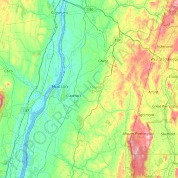
Name: Columbia County topographic map, elevation, terrain.
Location: Columbia County, New York, United States (41.97781 -73.92966 42.51003 -73.35244)
Average elevation: 196 m
Minimum elevation: -4 m
Maximum elevation: 782 m
Other topographic maps
Click on a map to view its topography, its elevation and its terrain.
Central Park
United States > New York > New York County > New York
In June 1856, Fernando Wood appointed a "consulting board" of seven people, headed by author Washington Irving, to inspire public confidence in the proposed development. Wood hired military engineer Egbert Ludovicus Viele as the park's chief engineer, tasking him with a topographical survey of the site. The…
Average elevation: 26 m
Tug Hill
United States > New York > Oswego County
The core Tug Hill region encompasses 150,000 acres (610 km2) of unbroken, generally second-growth, northern hardwood forest, and is drained by a vast network of streams. Important rivers and streams whose headwaters are located within the Tug Hill region include the Mohawk River, Deer River, Salmon River, Mad…
Average elevation: 109 m
Whiteface Mountain
United States > New York > Essex County
Whiteface Mountain is the fifth-highest mountain in the U.S. state of New York, and one of the High Peaks of the Adirondack Mountains. Set apart from most of the other High Peaks, the summit offers a 360-degree view of the Adirondacks and clear-day glimpses of Vermont and even Canada, where the skyscrapers of…
Average elevation: 1,090 m
Ontario Pond
United States > New York > Niagara County > City of North Tonawanda
Average elevation: 177 m
Hartmans Corners
United States > New York > Albany County > Town of Guilderland
Average elevation: 81 m
Inwood Hill Park
United States > New York > New York County > New York
Inwood Hill Park is a 196 acres (79 ha) public park in the Inwood neighborhood of Manhattan, New York City, operated by the New York City Department of Parks and Recreation. On a high schist ridge that rises 200 feet (61 m) above the Hudson River from Dyckman Street to the northern tip of the island, Inwood…
Average elevation: 14 m
Brooklyn Bridge Park
United States > New York > Kings County > New York
Brooklyn Bridge Park spans 85 acres (34 ha) of the East River waterfront in the Brooklyn Heights and Dumbo neighborhoods of Brooklyn. The park is divided into eleven sections: Piers 1 through 6; Fulton Ferry Landing; Brooklyn Bridge Plaza; Empire Fulton Ferry; Main Street; and John Street. Each of these…
Average elevation: 9 m
Sunset Ridge
United States > New York > Westchester County > Town/Village of Harrison
Average elevation: 27 m
North Germantown
United States > New York > Columbia County > Town of Germantown
Average elevation: 34 m
Catskills Visitor Center
United States > New York > Ulster County > Town of Shandaken > Beechford
Average elevation: 301 m
Ives Corner
United States > New York > Rensselaer County > Town of Poestenkill
Average elevation: 318 m
Jayne's Hill
United States > New York > Suffolk County > Town of Huntington
Jayne's Hill (also known as High Hill, West Hills, Oakley's Hill, and Janes Hill) is the highest point on Long Island, New York, with an elevation of between 387 feet (118 m) and 400.9 feet (122.2 m) above sea level. It is situated on the Harbor Hill moraine, a terminal moraine that makes up the northern spine…
Average elevation: 73 m
Boyntonville
United States > New York > Rensselaer County > Town of Pittstown
Average elevation: 202 m
Mount Hope
United States > New York > Westchester County > Village of Hastings-on-Hudson
Average elevation: 60 m
South Salem
United States > New York > Westchester County > Town of Lewisboro
Average elevation: 174 m
Worley Heights
United States > New York > Orange County > Village of South Blooming Grove
Average elevation: 213 m
Preston Hollow
United States > New York > Albany County > Town of Rensselaerville
Average elevation: 372 m
Barberville
United States > New York > Rensselaer County > Town of Poestenkill
Average elevation: 269 m
Upper Lansingburg Reservoir Dam
United States > New York > Rensselaer County > City of Troy
Average elevation: 92 m