
South Salem topographic map
Interactive map
Click on the map to display elevation.
About this map
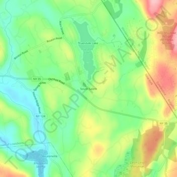
Name: South Salem topographic map, elevation, terrain.
Average elevation: 176 m
Minimum elevation: 118 m
Maximum elevation: 263 m
Other topographic maps
Click on a map to view its topography, its elevation and its terrain.
Goldens Bridge
United States > New York > Westchester County > Town of Lewisboro
Goldens Bridge, Town of Lewisboro, Westchester County, New York, United States
Average elevation: 94 m
Waccabuc
United States > New York > Westchester County > Town of Lewisboro
Waccabuc, Town of Lewisboro, Westchester County, New York, 10597, United States
Average elevation: 183 m